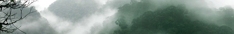
| El Parque Nacional Tapantí (PNT), que cuenta con 4 715 ha y la mayor cantidad de lluvias y nubes del país, se encuentra localizado al este del Valle Central de Costa Rica, 20 kms al sureste de la ciudad de Cartago. Debido a su posición geográfica en la vertiente septentrional (o Caribe) de la Cordillera de Talamanca, donde se ubica entre 1 200 y 2 450 metros sobre el nivel del mar, y por la incursión de la nubosidad a través del cañon del Río Reventazón, este parque registra en ciertas áreas hasta 8 000 mm anuales de lluvia, distribuidas por lo general a lo largo de todo el año y con una época relativamente más seca en los meses de marzo y abril. Unas 245 especies se han registrado. Entre la rica flora orquidácea predominan especies de la subtribu Pleurothallidinae, Epidendrum, Maxillaria, Oncidium, Elleanthus y Sobralia. El parque se encuentra a 27 km de Cartago sobre una calle de lastre via Paraíso-Orosi-Purisil-Tapantí-Oficinas del Parque.
Tapantí National Park (TNP), with 4.715 hectares and the greatest amount of rain and cloud cover in the country, is located in the eastern Central Valley in Costa Rica, 20 kms southeast of the city of Cartago. Because of its geographic position in the northern (or Caribbean) slopes of the Talamanca Mountain Range, where it lies between 1,200 and 2,450 meters above sea level,and the clouds from the sea that enter along the canyon of the Reventazón River, this park records annually up to 8,000 mm of rain in certain areas, distributed throughout the year and with a relatively dryer season during the months of March and April. About of 250 species have been recorded. Among the rich orchid flora of the park, you can observe many species of the subtribe Pleurothallidinae, as well as Epidendrum and Maxillaria, Oncidium, Elleanthus, and Sobralia. The Park is 27 km from Cartago along a semi-paved road via Paraíso-Orosi-Purisil-Tapantí-National Park Headquarters. |